

Traffic control
Automatic evaluation of traffic operations
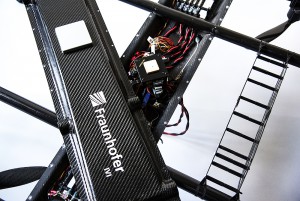
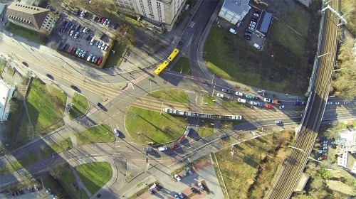
The Fraunhofer Institute is working on a method of traffic counting and evaluation of overtaking processes at busy hubs. The flight robot used here (based on MikroKopter technology) is in continuous use for up to 9 hours a day.
For further informations follow this link:
-> Project page of the Fraunhofer Institute
-> Drone from the Fraunhofer Institute with MK technology
Zoology
Killer whale watching project
The NOAA (National Oceanic and Atmospheric Administration) in joint with the Vancouver Aquarium using a HexaKopter for whale watching project. The purpose of the project was to monitor the health of the endangered Northern Resident killer whales. Here is a video of their work off the coast of British Columbia, Canada.
For more detailed information read the blog of the Vancouver Aquarium:
-> Research Site 1
-> Research Site 2
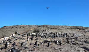
The MikroKopter in the Antarctic
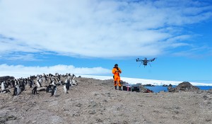
The ARF OktoXL in use in the Antarctic. The Thuringian Institute for Sustainability and Clima Protection (Think) investigates on the 15.000 flight miles away king George Island on the behalf of the Federal Environment Agenvy changes in penguin colonies.
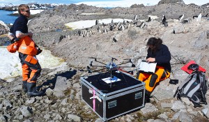
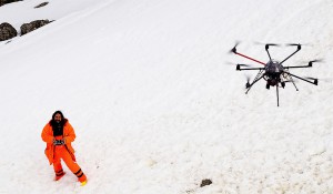
On the now 5th Research Expedition the researchers will use a research drone, in this case the OktoKopterXL, to take images of penguin colonies in different spectral ranges in order to get conclusions on the species composittion.
Meteorology
Meteodrones - weather research with the Mikrokopter
The prediction of weather situations is amazingly accurate these days. The situation is different, however, behaves with the assessment of local weather phenomena. Here the usual methods access only to a limited extent.
The company Meteo Matic has developed the "Meteodrones" in collaboration with the Federal Office for Civil Aviation. For the first time it is possible to determine temperature, humidity and wind conditions in the cload layer. For this purpose, a special aircraft was developed based on MikroKopter technology.
>>> More details Meteomatics Website
3km flight altitude thanks to MikroKopter technology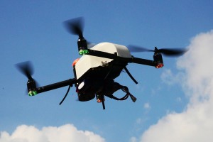
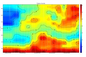
During the first test phase, over 100 test flights with the prototype took place in Payerne. The meteodrone flew up to a height of 3 km above ground to record temperature, humidity, pressure, wind speed and direction as vertical profiles.
Thanks to the approval of the FOCA, Meteomatics can now fly with the Meteodrones even in clouds and in fog. This means that there is nothing standing in the way of an extended test phase: With the data obtained, the development of an improved weather model, with which fog and storms can be predicted much better in the future, will continue.
Ultimately, that means that meteodrons are allowed to fly 3000 meters out of sight, which is so far unique in Switzerland.
Archeology
Hidden worlds
<
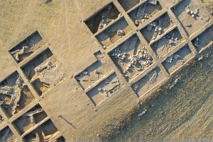
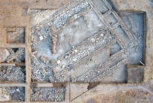
One application of the MikroKopter is the archeology. Many puzzle pieces of the past are brought back to the daylight in meticulous work. In many times the excavation area encompasses a very large area and the help of aerial pictures is needed to get an overview.
Aerial images can help, for example, to recognize shapes of settlements, building complexes, protective equipment, etc. The GPS positions of the MikroKopter are stored in logfiles, so the exact position of the photo can be georeferenced.
ZDF TV documentation
For a ZDF documentary stunning HD-videos of the Lost Kingdom of Arakan in today's Myanmar were recorded.
Geology
Remote Sensing with the Mikrokopter
With the help of the MikroKopter the company geoservices creates Orthophoto mosaics and elevation models. These elevation models reaching an resolution from 2 to 10 centimeters.
Based on a pre-established timetable grid the MikroKopter makes it possible to create systematic and coordinate-related images and measurement flights.
>>> more details on geoservice Webseite
Platform for carrying measuring instruments
The MikroKopter brings your measuring instruments into the air.
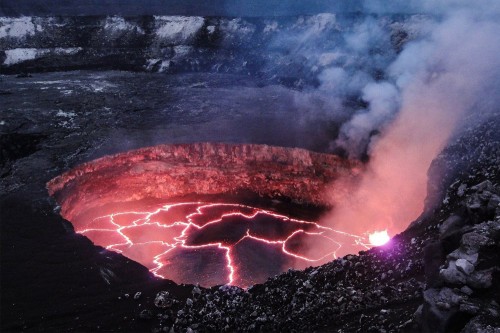
For example it measures the danger of gas clouds by fire or volcanic activity, without a risk for the usual helicopter pilots.
Geology and Land Survey
The applications of the MikroKopter are varied. MikroKopter can be equipped with appropriate hardware and be used for measurements, collecting environmental information, creating maps etc.
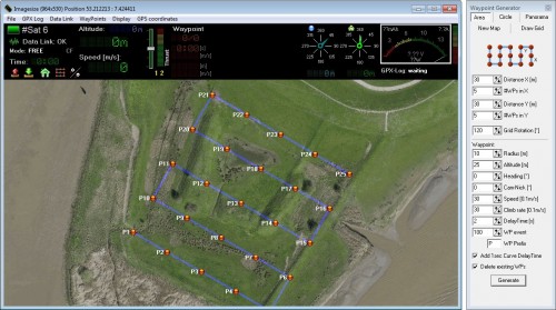
One of the central features of the MikroKopter is the waypoint flight. With the help of a GPS system, waypoints or POIs (Points of Interest) can be programmed on a PC or a tablet computer.
The flight can be planned at home or on the site. Load them into the MikroKopter and it will fly the route automatically. The fly plan can be stored easily and can be reused at any time.
The following video demonstrates how a Hexakopter helps createing a 3D model of an area :
Geodesy
Surveying and Geodesy

The use of Multikopter opens up the field of surveying and geodesy with new applications and increases the efficiency of conventional ways of working. In particular, in the gap between shots with manned aircraft and ground-based measurement technology (GPS, total stations, laser scanning, etc.) there are clear benefits: large-scale orthophotos, detailed height- and volume models as well as the data basis for the generation of local 3D models, can be generated mostly by aerial surveys with Multikopter.
In addition to the flight technical know-how and the right equipment, interdisciplinary knowledge in geodesy, photogrammetry and engineering is required for this. Geospector meets these requirements with over 20 years of experience as an engineering office, in an ideal way. For flight systems, the technique of Mikrokopter is used, because it is mature and extremely reliable in everyday projects. On the other hand it can be integrated through the open system architecture and interfaces well into the overall system.
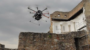
Example: From the real ruins to the 3D model
For example, a comprehensive documentation was created on the occasion of reorganization measures of a ruined castle [Overall view], which shows the situation before and after a partial reconstruction. Besides the Multicopter Flight Shots, the data material and images were also used from the ground and from a high tripod to get a complete coverage of those complex structures.
The procedure is as follows:
- Calibration of ground-based reference points by using GPS and total station [soil survey]
- Flight route by waypoints (about 200 vertical and oblique views) [ground station]
- Operational flight by Mikrokopter Okto and a calibrated Sony system-camera [flight Oktokopter MK]
- Georeferencing (position, camera-angles) and post-processing of the images
- Generating a high-density point cloud on a photogrammetric workstation [evaluation]
- Manual cleanup and post-processing of the point cloud
- Recovery of the final products: orthophoto and 3D models
To illustrate the process here a visualized photo gallery:
The orthophoto is a scaled and equalized "vertical image" with 150 mega pixels and with a ground resolution of 0.5 centimeters. The accuracy of the position and of all pixels in relation to the systems of land surveying, it is consistently better than two centimeters. The orthophoto can be used directly as a basis for the creation of a highly accurate floor plan of the castle. As a side-product in the photogrammetric evaluation on an elevation model, it can be used for example in the case of gravel pits or quarries for volume determinations.
The 3D model [model mesh, texture model] is rotatable around all three axes anywhere in space.In addition to visualization and presentation purposes it can be transferred directly to the involved
CAD systems planners. Therefor the identification and establishment of the remedial measures are simplified.
MulDiScan
MulDiScan - Early detection of natural disasters
Scientists at the Fraunhofer Institute for Physical Measurement Techniques IPM and the AlbertLudwigsUniversity Freiburg are working under the project name "MulDiScan" to predict better such as floods, landslides and forest fires in the future.
The collection of data are highly accurate measurements of the geometry based on light propagation measurements. For these measurements from the air, the MikroKopter is perfect to measure those just hard to reach landscapes. For the use in the air, a particularly lightweight laser scanner is used, which can detect the geometry of the terrain very effectively from the air.

>>> Project Page of the Fraunhofer Instituts (IPM) (German)
>>> Laserscanning Webseite of the Fraunhofer Institut